Overview of a Tile Server
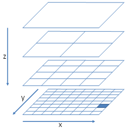
Tile services provide a grid of uniformly sized images (typically 256x256 pixels) with a different set of images for each zoom level / resolution.
Each tile is uniquely identified by the combination of row (y) and column (x) of that tile in the grid for the zoom level (z).
The URL for a tile is found by taking these values and substituting them into a placeholder in the "url" parameter provided in the map layer setting. For example, if the url in the setting is set to:
"http://stratus.ondemand.eu/connect/gettile?mapcfg=Main&name= Base&level=${z}&row=${y}&col=${x}&output=image/gif"
Then the URL generated for zoom level 3, row 5 and column 7 would be:
"http://stratus.ondemand.eu/connect/gettile?mapcfg=Main&name= Base&level=3&row=5&col=7&output=image/gif"
In order to work out the column, row and zoom of the tile that need to be specified for a particular map coordinate (x,y) it goes through the following process:
- The zoom is set to the zoom level. Zero is the most zoomed out level.
- The resolution is determined from the zoom level.
- The distance of the x and y from the tile origin is determined (top left corner of the maximum extent of the map).
- These distances are converted to pixels by dividing them by the resolution
- The distances in pixels are then divided by the tile size and rounded down to determine the row and column.
For example, if a Tile server had an origin of 0,1000000 a tile size of 256x256 pixels and resolutions 1000,500,250,125 then the row and column for point 400000,300000 at the second most detailed zoom level would be calculated as follows:
- Zoom is 1 (as the least detailed zoom level is zero).
- The resolution is 500 (second item in the list of resolutions).
- Distance from origin is 400000 for x and 700000 for y (1000000 – 300000).
- These distances in pixels are 800 for x and 1400 for y.
- The column is therefore 3 (800 / 256, is 3.125 rounded down) and the row is 5.
In the above example, this would generate the following URL:
"http://stratus.pbondemand.eu/connect/gettile?mapcfg=Main&name= Base&level=1&row=5&col=3&output=image/gif"